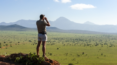


Uganda is often framed through a narrow lens. The spotlight tends to fall on its national parks, primate tracking, and wildlife photography circuits. These assets carry value, but they tell only part of the story. Beyond the boundaries of protected areas lies a less-documented layer of natural and cultural geography. Scattered across Uganda are sites that remain largely undocumented in mainstream tourism literature: isolated waterfalls tucked into escarpments, limestone caves once used as places of refuge or ceremony, and forest trails that function more as memory routes than as mapped attractions.
These spaces often fall outside regulated circuits and require local interpretation to be accessed meaningfully.
They aren’t hidden because of inaccessibility alone, it is also because the tourism economy doesn’t prioritise them. And in some ways, that has preserved their integrity. Without the scaffolding of commercial promotion, many of these places remain embedded in local knowledge systems — visited for reasons that are social, spiritual, or ecological rather than recreational.
This article traces those lesser-seen sites. It focuses on select waterfalls and cave systems not yet drawn into mass tourism. The goal is not simply to inform but to shift the gaze — to advocate for a deeper kind of engagement with place, one built on patience, respect, and contextual awareness.
Why Uganda’s Caves and Waterfalls Are Overlooked
The absence of caves and waterfalls from Uganda’s mainstream tourism narrative isn’t accidental. It stems from how the tourism boards develop, market and consume these destinations.
A Tourism Economy Built Around Flagship Species
Tourism in Uganda has followed a model common in many parts of East Africa: wildlife-first.
The presence of iconic species — mountain gorillas, chimpanzees, elephants, and lions — has shaped both international perception and investment.
This has resulted in a concentration of tourism infrastructure and resources in a limited number of locations. Bwindi Impenetrable National Park, Kibale Forest, and Murchison Falls consistently receive attention because they align with the global demand for wildlife-based experiences.
Caves and waterfalls do not easily integrate into this wildlife-centric product.
They lack the universal marketing appeal of charismatic megafauna and do not benefit from the same level of conservation financing.
As a result, they remain peripheral in destination planning, even when they hold ecological, cultural, or geological significance.
Limited Infrastructure and Accessibility
Many of Uganda’s lesser-known caves and waterfalls are in districts with minimal road access, weak digital connectivity, and inconsistent visitor services.
These are often rural zones where transportation means are foot traffic or motorcycles, and signage is absent. For an international visitor unfamiliar with the area, reaching these sites without local support can be logistically complex.
Tourism development tends to follow infrastructure.
Where there are roads, accommodations, and trained guides, there is market potential. Without these elements, sites — regardless of their value — struggle to receive visitors or recognition.
The issue is not always physical inaccessibility, but rather a lack of institutional investment in making these places legible and safe for visitation.
Read Also: Other Fascinating Wildlife in Uganda and Rwanda
Cultural Context and Restricted Access
Unlike national parks, many cave and waterfall sites exist within local or clan jurisdictions.
Access is governed by oral rules rather than legal frameworks. Some caves are sacred or are actively for cultural practices.
Entry might be restricted by gender, time of year, or spiritual condition. Similarly, waterfalls can serve ceremonial or social functions that require discretion and respect.
When tourism frameworks ignore these contextual layers, they risk disrupting the relationships communities have with these places.
In many cases, the decision to leave a site undeveloped reflects an intentional choice to protect it — not from outsiders, but from misinterpretation.
Conservation and Destination Development Priorities
In the eyes of policy planners and development agencies, caves and waterfalls often fall outside conservation priorities unless they intersect with ecological zones of strategic interest.
Wetlands, forest reserves, and river catchments receive funding because of their environmental services. Geological features or cultural landmarks without clear economic outputs struggle to attract similar support.
Tourism investment tends to follow the path of least resistance. High-traffic destinations justify road construction, visitor centers, and hospitality development.
Lesser-known sites, particularly those without a clear economic model, remain overlooked in planning documents and tourism master plans.
While not yet part of most itineraries, waterfalls and caves in Uganda offer unique cultural insights and raw natural beauty unmatched by typical safari routes.
Waterfalls
Sipi Falls
Sipi Falls is a series of three distinct waterfalls located on the northwestern slopes of Mount Elgon in eastern Uganda, near the town of Kapchorwa. The falls are at varying altitudes, with the main waterfall dropping approximately 100 meters, making it the most prominent of the trio. The surrounding area offers panoramic views of the Karamoja plains.
Unique Features
- Three-Tiered Waterfalls: The Sipi Falls consists of three separate waterfalls, each with its unique character and appeal.
- Hiking Trails: The area boasts well-developed trails that cater to both novice and experienced hikers, offering routes that traverse local communities, coffee plantations, and caves.
- Rock Climbing: The cliffs around the falls provide opportunities for rock climbing, with established routes suitable for various skill levels.
Cultural Significance
The Sipi area is predominantly inhabited by the Sabiny people, who have a rich cultural heritage. The name “Sipi” is derived from the local plant known as “Sep,” a medicinal plant resembling a wild banana that grows along the riverbanks.
According to local lore, early European explorers misinterpreted the name when inquiring about the area, leading to the current name, Sipi. Visitors have the opportunity to engage with the community, learn about traditional practices, and participate in coffee tours, as the region is renowned for its Arabica coffee cultivation.
Aruu Falls
Aruu Falls is located in Pader District in northern Uganda, approximately 386 kilometers from Kampala. The falls are characterized by a series of cascading streams tumbling over large rocks, creating a picturesque and serene environment. The surrounding landscape is dotted with lush vegetation and offers a tranquil retreat from urban life.
Unique Features
- Multi-Tiered Cascades: Unlike a single-drop waterfall, Aruu Falls features multiple cascades flowing over a series of rock formations, creating natural pools suitable for swimming.
- Bird Watching: The area around the falls is home to various bird species, making it a favorable spot for bird enthusiasts.
Sezibwa Falls
Sezibwa Falls is in Mukono District, approximately 32 kilometers east of Kampala along the Kampala-Jinja highway. The falls are part of the Sezibwa River, which flows from the wetlands between Lake Victoria and Lake Kyoga. The river cascades over a series of rocks, creating a 7-meter drop into a serene pool below.
Cultural Significance
According to Buganda legend, the Sezibwa River was born of a woman named Nakangu Tebatuusa, who, instead of human children, gave birth to twin rivers—Sezibwa and Bwanda. This event apparently imbued the river with spiritual powers.
The falls are a sacred site to the Baganda people, with many visiting for blessings, healing, and traditional rituals. Shrines and offerings are all over the site, reflecting its deep-rooted cultural and spiritual significance.
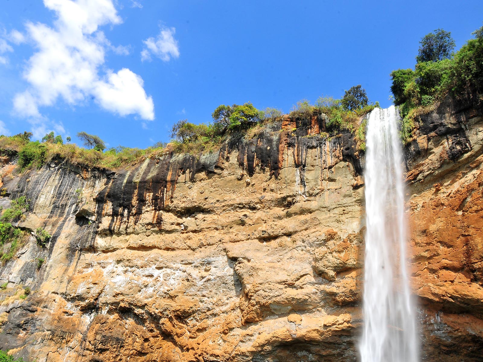
Kisiizi Falls
Kisiizi Falls is located in Rukungiri District in southwestern Uganda, within the Kigezi highlands.
The waterfall forms along the Rushoma River, which cuts through a narrow gorge before dropping approximately 30 meters. The surrounding environment features steep ridges, subsistence farms, and patches of forest, creating a landscape that feels both intimate and remote.
Hydrological Function and Local Use
The falls drive a small hydroelectric station operated by Kisiizi Hospital, located nearby.
This installation supplies electricity not just to the hospital but to schools and households in the area as well. It stands as a rare example of decentralized energy infrastructure directly benefiting a rural population.
Unlike larger waterfalls developed strictly for viewing, Kisiizi Falls supports everyday life. That practical dimension gives the site a level of relevance not often visible in locations marketed only for outside visitation.
Social Memory and Historical Significance
Kisiizi Falls carries a historical burden. Oral accounts from the region recall a time when families brought unmarried young women who had conceived outside of sanctioned relationships to the edge of the falls.
They were pushed to their deaths in acts presented as discipline or moral correction. This practice, while now condemned and long abandoned, formed part of the region’s social code before broader reforms in education, religion, and health services.
Today, a memorial stands near the site. It offers a focal point for community discussions about gender, dignity, and generational change.
Educators and religious leaders use the story of Kisiizi Falls to confront past injustice and advocate for more humane responses to issues of sexuality and family structure.
Itanda Falls
Itanda Falls is located along the White Nile River in Jinja District, eastern Uganda. Approximately 27 kilometers northwest of Jinja town, the falls can be reached via a 45-minute drive through rural landscapes.
The journey offers insights into local life and culminates at a site where the Nile’s waters surge over a series of rapids.
Distinctive Features
- Powerful Rapids: Itanda Falls is characterized by a sequence of challenging rapids, some reaching Grade 6, showcasing the river’s formidable strength.
- Scenic Environment: The falls are enveloped by lush vegetation and unique rock formations, providing a picturesque setting for visitors.
Activities and Experiences
- White-Water Rafting and Kayaking: The intense rapids attract adventure enthusiasts for high-adrenaline rafting and kayaking experiences.
- Bird Watching: The surrounding area is a habitat for diverse bird species, offering birding opportunities.

Caves
Garama Cave
Garama Cave lies within Mgahinga Gorilla National Park in southwestern Uganda, near the border with Rwanda.
The entrance is a short walk from the park’s main gate in Ntebeko. Though the path is gentle, it winds through highland forest often shrouded in mist. The altitude hovers around 2,200 meters above sea level, giving the area a cool, damp feel year-round.
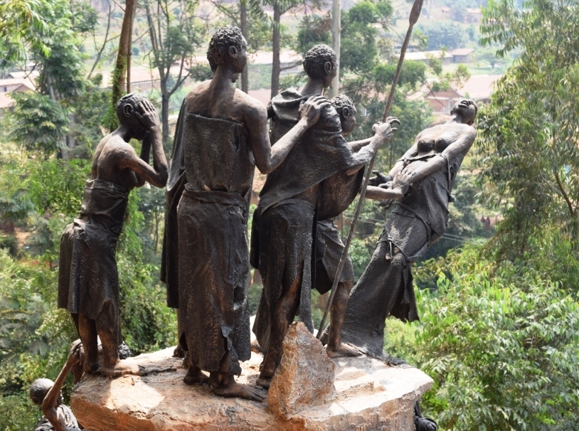
How the Batwa Used It
This cave served as a key refuge for the Batwa — forest-dwelling hunter-gatherers who lived in the Virunga Mountains long before the area became a national park.
During raids or conflict, Batwa families would hide deep inside the darkness of Garama. Decisions about hunting, territory, and survival happened in this space, under the cover of rock.
After the Batwa were evicted from the park in the 1990s, the cave lost its function but not its meaning. Today, it remains a symbol of identity and struggle.
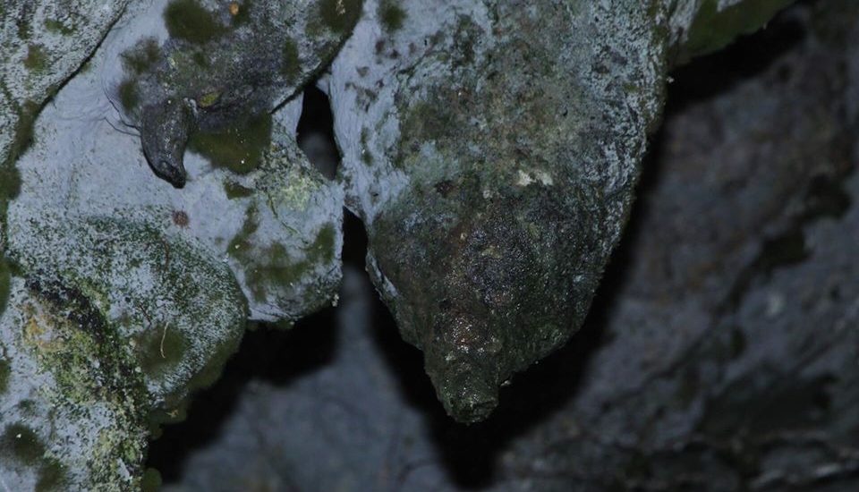
The main chamber stretches over 300 meters. Inside, it’s cool and completely dark — no ambient light filters in. The floor is uneven in places, and bat colonies cling to the walls.
When Batwa guides sing traditional songs at the entrance, the sound travels through the chambers with eerie clarity.
Amabere Ga Nyina Mwiru Caves
Amabere Ga Nyina Mwiru sits just outside Fort Portal in western Uganda, in the Nyakasura area beneath the foothills of the Rwenzori Mountains.
The cave system is part of a limestone formation shaped over centuries by mineral-rich water dripping through the rock. Nearby waterfalls and a small crater lake contribute to the ecological setting, creating a site that combines geological interest with cultural meaning.
The caves lie within private land but are open to the public under locally managed access arrangements.\
Site Characteristics
Inside the cave, mineral deposits have formed prominent stalactites and stalagmites, which continue to grow slowly through calcium-laden water. The formations are active, meaning water continues to seep through and deposit minerals, giving the space a damp, reflective quality.
Cultural Interpretation
The cave takes its name from a deeply rooted oral legend in the Toro Kingdom.
According to the story, King Bukuku of the Batembuzi dynasty cut off the breasts of his daughter, Nyina Mwiru, to prevent her from becoming pregnant. She later gave birth in secret. Locals believe the stalactites in the cave resemble dripping breast milk — hence the name Amabere ga Nyina Mwiru, or “the breasts of Nyina Mwiru.”
Nyero Caves
Nyero Caves are located in Kumi District in eastern Uganda, approximately 250 kilometers from Kampala and 8 kilometers from Kumi town.
The caves sit within a cluster of granite outcrops that rise above the surrounding flat landscape — a geographic anomaly in an otherwise open region. This positioning has long made the caves a natural point of orientation and gathering.
The site has three primary shelters: Nyero 1, Nyero 2, and Nyero 3 — each distinct in form and layout.
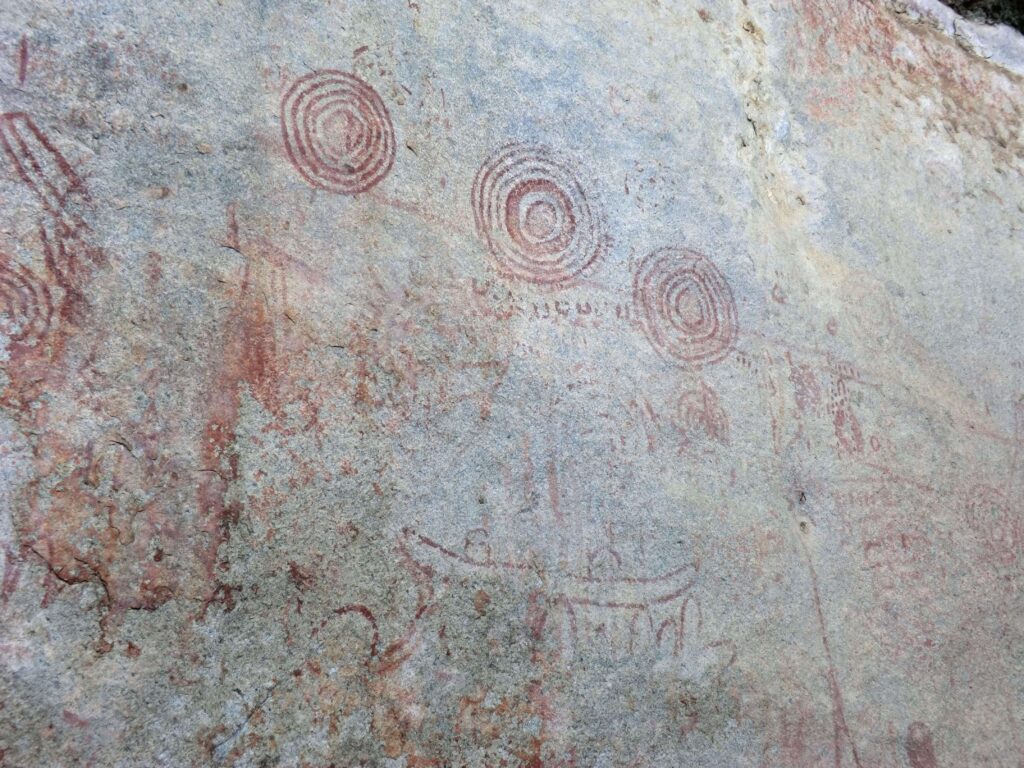
Archaeological Significance
Nyero is among the most important rock art sites in Uganda. The paintings, done in red pigment derived from iron oxide, reflect stylistic patterns associated with early hunter-gatherer societies believed to date back over 1,000 years.
Most images take geometric forms — concentric circles, dotted lines, and ladder-like symbols — rendered with remarkable consistency.
The placement of the art on vertical and angled rock surfaces suggests intentionality, though their specific meanings remain open to interpretation.
Researchers have linked Nyero’s style to broader traditions of rock art across East and Southern Africa, indicating historical connections between ancient communities across regions.
Local Perspectives and Cultural Layers
While the origins of the art may predate current communities, local interpretations remain strong.
Elders in Kumi refer to the caves as sacred, often describing them as places of ancestral presence. In some accounts, people visited the caves to seek protection, guidance, or fertility.
Oral narratives vary, but many include references to the caves as points of retreat in times of conflict or drought. Some families still make symbolic offerings near the shelters during times of difficulty, especially at Nyero 2, the largest and most enclosed of the shelters.
This blend of archaeological heritage and living tradition gives the site a dual identity: part historical archive, part spiritual landscape.
Kaptuura Caves
The Kaptuura Caves are located in Kapchorwa District, on the western slopes of Mount Elgon in eastern Uganda. This is highland country, where steep ridges and deeply cut valleys dominate the landscape.
The caves lie within Tumbaboi Village, several kilometers from the trading center of Tegeres. At roughly 2,400 meters above sea level, the area remains cool throughout the year, with low-hanging clouds common during the rainy season.
The surrounding zone is largely agro-pastoral, with cattle keeping and small-scale farming as primary livelihoods.
Current Use and Traditional Function
Unlike other caves that serve primarily as heritage sites or points of interest, Kaptuura Caves remain in active use.
Local herders from the Sebei community use the shelters seasonally when moving livestock to higher grazing zones. During these months, the caves serve both as living quarters and as protection for cattle from rain and predators.
The shelters are simple — some enclosed by wooden fencing, others left open — but they represent a living tradition of vertical migration and adaptation to highland ecology. This form of seasonal residence links closely with indigenous knowledge systems and sustainable grazing practices.
Conclusion: Looking Beyond the Familiar Map
There’s a difference between visiting a place and learning how to see it.
Uganda’s caves and waterfalls don’t announce themselves. They don’t sit behind entrance gates or on the usual safari loops. Instead, they ask for time, attention, and a willingness to move slowly.
Not everything worth seeing fits into standard itineraries — and not every place benefits from being turned into a destination.
For those working in tourism, conservation, or cultural preservation, these sites offer something more than attraction value. They challenge how we define significance.
They remind us that geography alone doesn’t create meaning — people do. And that meaning often exists well before a guidebook ever mentions it.
To explore these places well is to listen as much as to look. What remains unmarked on maps is often already known by someone. The work — and the reward — lies in learning to follow that knowledge with respect.